14
powder magazines, secondary roads, haul roads, and power line. The layout of the Hydromet
Plant and TSF at the Upton Site is provided in Appendix A.
4.5
PROJECT DESCRIPTION
4.5.1 Land Requirements
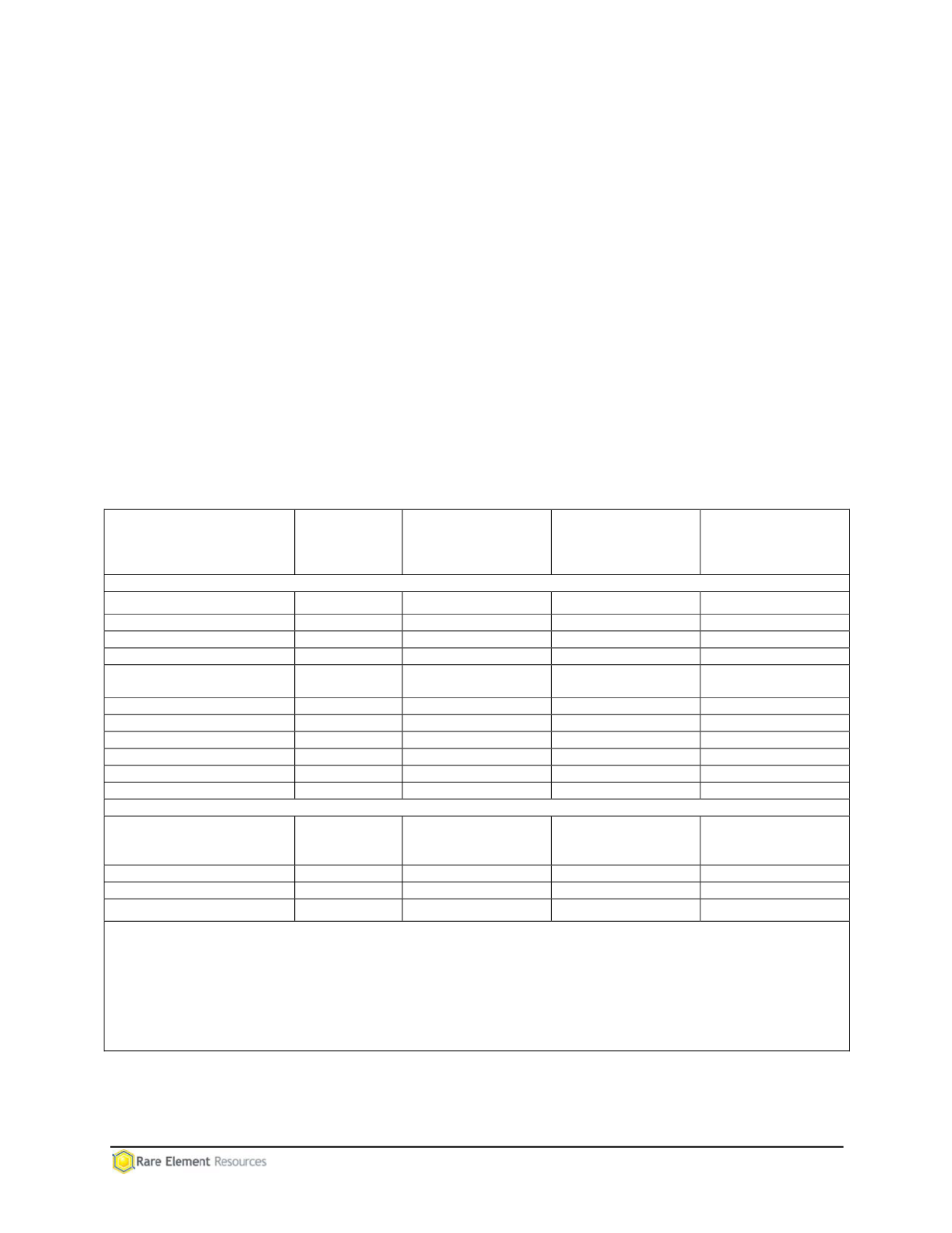
Proposed facilities and infrastructure within the Project Area are shown on Map 4.2-2 (map
pocket). Surface disturbance within the Project Area totals 899.23 acres (460.82 acres on
Forest Service land) as shown in Table 4.5-1. All of the surface disturbance for major
components will be located on land administered by the Forest Service except for the Waste
Rock Facility (including the Low Grade Ore Stockpile), the Sediment Trapping Ponds, and a
portion of the Haul Road.
Outside of the Project Area, upgrading of the Miller Creek Access Route will require an
estimated 81.67 acres of disturbance (31.64 acres on Forest Service lands, 7.85 acres on State
of Wyoming lands, and 42.18 acres on private lands). The power line will require an estimated
36.73 acres of disturbance (3.03 acres on Forest Service lands, 12.97 acres on State of
Wyoming lands, and 20.73 acres on private lands).
Table 4.5-1
Estimated Surface Disturbance Required for the Bull Hill Mine
Project Component
Total
Proposed
Disturbance
(acres)
Proposed
Disturbance
Federal Lands
(acres)
Proposed
Disturbance
State Lands
(acres)
Proposed
Disturbance
Private Lands
(acres)
Within Project Area Boundary
Physical Upgrade Plant
176.32
176.32
0.00
0.00
Mineable Pit
231.6
231.6
0.00
0.00
Waste Rock Facility
425.98
0.00
0.00
425.98
Sediment Trapping Ponds
14.18
4.42
0.00
9.76
Low Grade
Ore Stockpile
1
0.00
0.00
0.00
0.00
Topsoil Stockpiles
2
18.40
18.40
0.00
0.00
Water Line
3
0.89
0.89
0.00
0.00
Secondary Road
4
5.92
5.92
0.00
0.00
Haul Road
5
9.70
7.03
0.00
2.67
Power Line
6
16.24
16.24
0.00
0.00
Total
899.23
460.82
0.00
438.41
Outside of Project Area Boundary
Upgrading Miller Creek
Access Route – Secondary
Road
7
81.67
31.64
7.85
42.18
Power Line
36.73
3.03
12.97
20.73
Total
118.40
34.67
20.82
62.91
Grand Total
1,017.63
495.49
20.82
501.32
1
Acreage for low grade ore stockpile (70 acres) is noted as 0.00 because it is contained entirely within the Waste
Rock Facility.
2
Acreage does not include Topsoil Stockpile #1 because it is within the PUG boundary.
3
Assumes 25 ft. disturbance width for pipeline construction.
4
Assumes 80 ft. disturbance width and does not account for existing road disturbance.
5
Assumes 100 ft. disturbance width and does not account for existing road disturbance.
6
Disturbance is temporary for 100 ft. right-of-way. Long-term disturbance would be required for pole structures.
7
Assumes 80 ft. disturbance width for 11.23 miles with 20 ft. of existing road disturbance.


