3
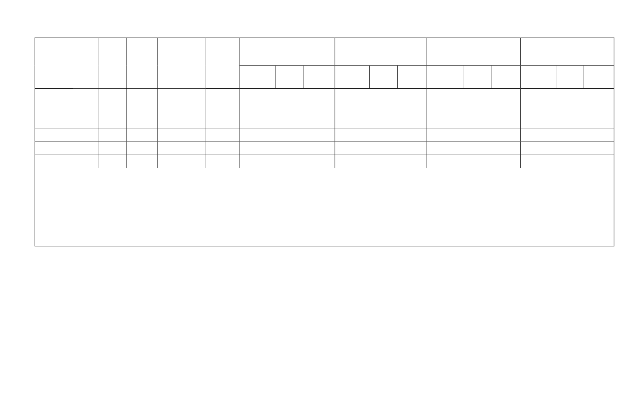
Location
Name
Easting Northing Elevation
(ft amsl)
Installation Date
Number of
Samples
Taken
Through
Mid-
September
2012
Nov 2011
Dec 2011
Jan 2012
Feb 2012
Field
Parameters
Stream
Gauging
Sample
Collected
Field
Parameters
Stream
Gauging
Sample
Collected
Field
Parameters
Stream
Gauging
Sample
Collected
Field
Parameters
Stream
Gauging
Sample
Collected
UCC1
4
526707 4884198
ND
Grab Sample
Only
2
SITE NOT ESTABLISHED
SITE NOT ESTABLISHED
SITE NOT ESTABLISHED
SITE NOT ESTABLISHED
UCC2
4
526718 4884209
ND
Grab Sample
Only
2
SITE NOT ESTABLISHED
SITE NOT ESTABLISHED
SITE NOT ESTABLISHED
SITE NOT ESTABLISHED
UCC3
4
527235 4882391
ND
Grab Sample
Only
2
SITE NOT ESTABLISHED
SITE NOT ESTABLISHED
SITE NOT ESTABLISHED
SITE NOT ESTABLISHED
USP1
4
526132 4883659
ND
Grab Sample
Only
1
SITE NOT ESTABLISHED
SITE NOT ESTABLISHED
SITE NOT ESTABLISHED
SITE NOT ESTABLISHED
USP2
4
526889 4884140
ND
Grab Sample
Only
1
SITE NOT ESTABLISHED
SITE NOT ESTABLISHED
SITE NOT ESTABLISHED
SITE NOT ESTABLISHED
USP3
4
527000 4884180
ND
Grab Sample
Only
1
SITE NOT ESTABLISHED
SITE NOT ESTABLISHED
SITE NOT ESTABLISHED
SITE NOT ESTABLISHED
Notes:
1
Insufficient sampling equipment or stream was dry.
2
Upton sites sampled on a quarterly basis
3
One time sample only
4
Upton sample sites not equipped with gauging stations
5
Sample event and results not confirmed by September 15, 2012
X = gauged during visit
● = not gauged during visit: low flow or frozen conditions
NA= Not Applicable
NC= Not calculated for 3 or fewer samples
ND= No Data
Datum: NAD83 Coordinate system: UTM, Zone 13N
ft amsl = feet above mean sea level


