1
Table 2
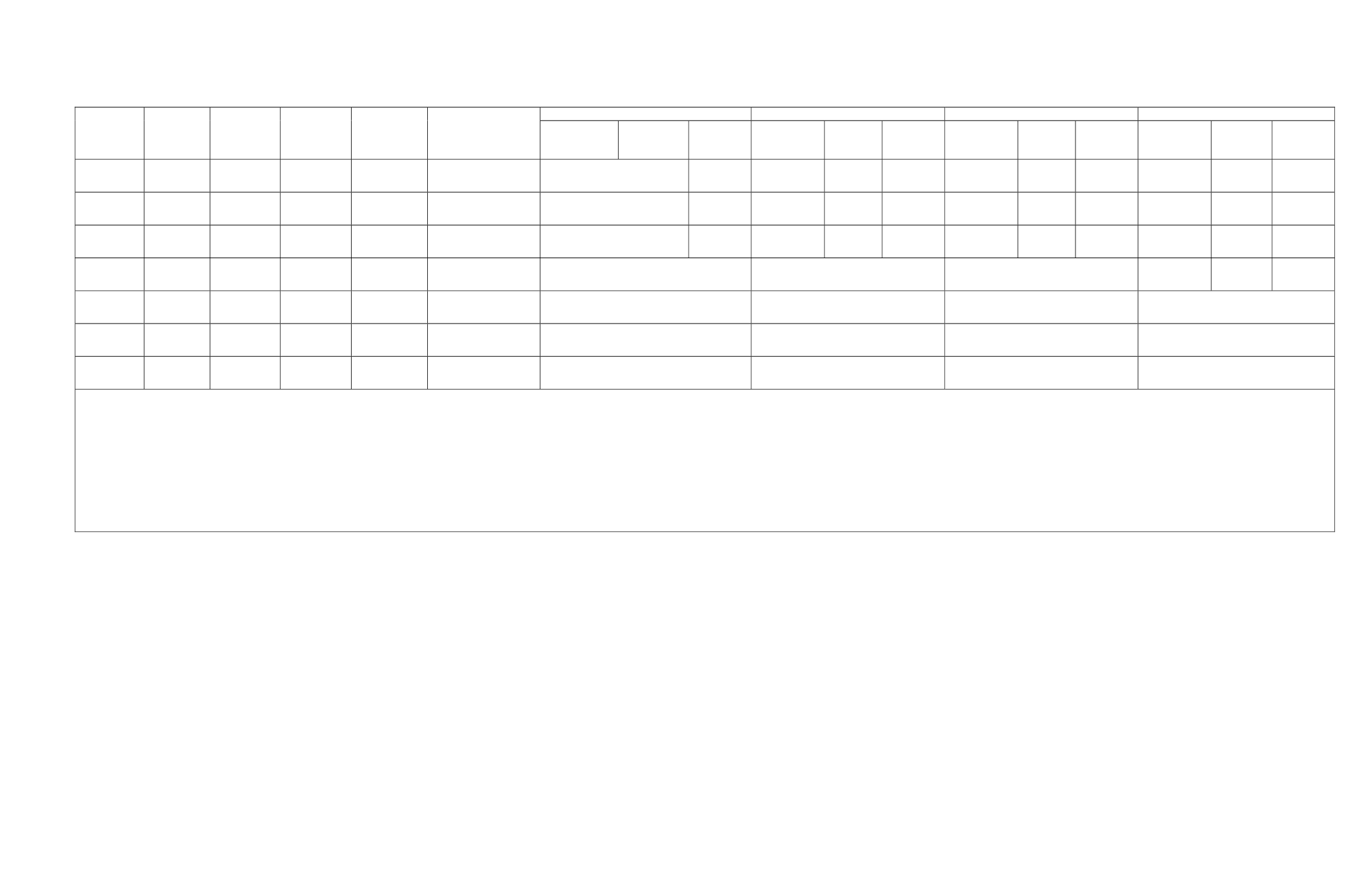
Surface Water Flow and Sampling Events Measurement Summary
Location
Name
Easting
Northing
Elevation
(ft amsl)
Installation
Date
Number of
Samples Taken
Through Mid-
September 2012
Nov 2010
Mar 2011
May 2011
June 2011
Field
Parameters
Stream
Gauging
Sample
Collected
Field
Parameters
Stream
Gauging
Sample
Collected
Field
Parameters
Stream
Gauging
Sample
Collected
Field
Parameters
Stream
Gauging
Sample
Collected
SGS-1
546455
4928118
5666.6
11/4/2010
19
INSTALLED
11/6/2010 pH, Temp,
Conductivity
X
3/14/2011 pH, Temp,
Conductivity
X
5/17/2011 pH, Temp,
Conductivity
X
6/17/2011
SGS-2
545862
4928682
5589.9
11/5/2010
19
INSTALLED
11/6/2010 pH, Temp,
Conductivity
X
3/14/2011 pH, Temp,
Conductivity
X
5/17/2011 pH, Temp,
Conductivity
X
6/17/2011
SGS-3
545206
4928166
5713.1
11/5/2010
19
INSTALLED
11/6/2010 pH, Temp,
Conductivity
X
3/14/2011 pH, Temp,
Conductivity
X
5/17/2011 pH, Temp,
Conductivity
X
6/17/2011
SGS-4
545827
4926536
5819
6/15/2011
4
NOT INSTALLED
NOT INSTALLED
NOT INSTALLED
INSTALLED X
3
SGS-5
544044
4927430
ND
8/15/2011
14
NOT INSTALLED
NOT INSTALLED
NOT INSTALLED
NOT INSTALLED
SGS-6
544038
4927620
5896
8/15/2011
14
NOT INSTALLED
NOT INSTALLED
NOT INSTALLED
NOT INSTALLED
SGS-7
542328
4926244
ND
12/16/2011
2
NOT INSTALLED
NOT INSTALLED
NOT INSTALLED
NOT INSTALLED
Notes:
1
Sample not obtained due to weather preventing access.
2
Dec. 2011 samples taken in early Jan. due to weather preventing access.
3
Insufficient sampling equipment or stream was dry.
X = gauged during visit
● = not gauged during visit: low flow or frozen conditions
NA= Not Applicable
NC= Not calculated for 3 or fewer samples
ND= No Data
Datum: NAD83 Coordinate system: UTM, Zone 13N
ft amsl = feet above mean sea level


